
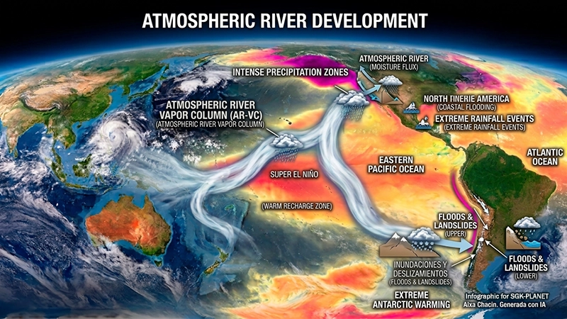
What are atmospheric rivers and how do they work?
The term “atmospheric river” (AR) has appeared in scientific records since the 1990s. The American Meteorological Society (AMS) added it to its meteorology glossary in 2017.
Atmospheric river: A long, narrow, and transient corridor of intense horizontal water vapor transport, typically associated with a low-level jet stream preceding the cold front of an extratropical cyclone. (AMS, 2017)
Atmospheric rivers are long, concentrated zones in the atmosphere that serve as sources of tropical and/or extratropical moisture. They are Earth’s largest “rivers” of fresh water, with a flow rate double that of the Amazon River.
When they make landfall, especially in mountainous areas with strong winds and low temperatures, the moist air condenses, producing heavy rain and snowfall. If the terrain is low-lying and temperatures are warm, the moisture arrives instead as high humidity, clouds, or mist.
Where do atmospheric rivers form, and which regions do they affect?
According to the AMS, atmospheric rivers are located in the lower troposphere, between 1,000 and 3,000 meters above sea level. They concentrate in mid-latitudes, below an atmospheric pressure level of 700 hPa (about 3,000 meters). This is where 75% of the water vapor flux is transported.
They are indeed observed over major oceans and in both hemispheres. Specifically, they extend from the ocean directly over coastal or continental mountain ranges and—moving from tropical and subtropical regions—toward temperate and polar zones.
Regions of the planet most affected by atmospheric rivers
- West Coast of North America: Found in the U.S. and Canada, stretching from Oregon and Washington down to California; a heavily studied region.
- West Coast of South America: Located in central and southern Chile, where it is subject to constant impacts originating from the South Pacific.
- Western Europe: Driven by moisture from the Caribbean or the subtropical Atlantic toward the United Kingdom, Ireland, Portugal, Spain, and France.
- Southwest Africa and Oceania: Occur when the Southern Alps block water vapor over the southwestern coast of South Africa, southern Australia, and New Zealand’s South Island.
- Antarctica and the Arctic: The cold, dry polar regions trigger temperature spikes and ice melt in Greenland and Antarctica.
Impact of Atmospheric Rivers and Climate Change
The primary cause of extreme precipitation is the intensified development of atmospheric rivers (ARs). These phenomena trigger severe flooding in mid-latitude western coastal regions worldwide. Conversely, their location and limited impact in some areas are linked to droughts in parts of the globe.
It is now known that ARs transport more than just water vapor. In 2021, evidence showed that Saharan dust traveled from Africa to Europe; it darkened snow in the Alps, reduced its reflectivity, increased heat absorption, and decreased snow depth by up to 50%.
Changes in wind patterns have a limited impact and vary by region because temperature changes, driven by global warming, vary regionally.
Subsequent studies project that ARs will become more frequent, intense, and long-lasting, with shorter intervals between landfall events. The magnitude of these events will vary by region and season. Frequency will increase by mid-century due to the increase in temperature on the Earth’s surface, as a consequence of global warming.
Consequences for the planet: Between drought relief and extreme events
Life on Earth depends on water. Atmospheric rivers account for more than 90% of global water vapor transport in the meridional (north-south) zone, though less than 10% in extratropical regions. They contribute approximately 22% of total global runoff.
Recent studies demonstrate the close relationship between moisture transport, heat, and the complex topography atmospheric rivers encounter along their paths. Predicting where and how intensely rain and snowfall will occur is crucial, as is forecasting and managing recurrent droughts.
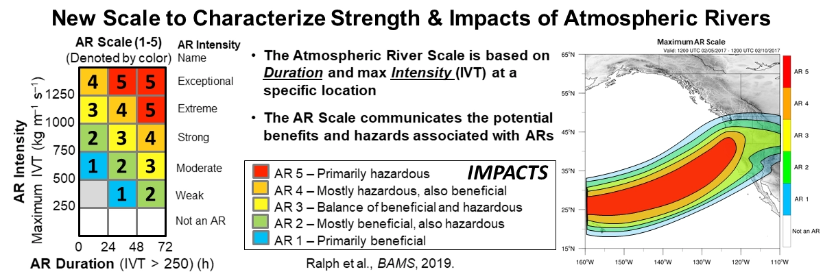
In 2019, F. Martin Ralph and colleagues developed a five-category scale that more clearly illustrates atmospheric rivers’ capacity and impact. Unlike the hurricane scale, it treats duration as a fundamental factor.
Conclusion: The Importance of Monitoring Atmospheric Water Highways
Understanding atmospheric river (AR) dynamics is crucial for disaster prevention and mitigation. Changes in their characteristics can increase the risk of heavy precipitation in regions where such events were previously infrequent, shifts driven primarily by rising atmospheric moisture levels.
Wind pattern changes have limited impact and vary by region because temperature fluctuations drive these regional differences; global warming, the primary cause of climate change, drives these temperature changes.
Understanding the processes behind extreme weather events will enable us to improve early warning systems. Likewise, proactive measures against floods, river surges, and landslides can reduce the risks frontal systems pose across the globe.
Continuous monitoring of these atmospheric phenomena is essential for predicting floods and droughts, as well as potential threats to populations’ access to potable water. Such monitoring would help prevent major humanitarian catastrophes.
Aixa Chacin
Editorial Director, SGK-PLANET
Sources consulted
Cao, Q. (2024, January 30). What is an atmospheric river? A hydrologist explains the good and bad of these storms and how they’re changing. The Conversation. https://theconversation.com/what-is-an-atmospheric-river-a-hydrologist-explains-the-good-and-bad-of-these-storms-and-how-theyre-changing-222249
Francis, D., Fonseca, R., Nelli, N., Bozkurt, D., Picard, G., & Guan, B. (2022). Atmospheric rivers drive exceptional Saharan dust transport towards Europe. Atmospheric Research, 266, Artículo 105959. https://doi.org/10.1016/j.atmosres.2021.105959
Hardach, S. (2024, 20 de noviembre). Atmospheric Rivers: Inside the giant ‘sky rivers’ swelling with climate change. BBC. https://www.bbc.com/future/article/20240509-how-to-forecast-the-next-atmospheric-river-storms?_x_tr_hist=true
Lu, M., Song, Y., Huang, W., & Zhang, L. (2025). Atmospheric rivers emerge as future freshwater reserves and heat stocks. Communications Earth & Environment, 6(1), Artículo 825. https://doi.org/10.1038/s43247-025-02780-6
Molina, P. (2026, 11 de febrero). Qué es un río atmosférico, cómo se forma y por qué afecta tanto a España. National Geographic España. https://www.nationalgeographic.com.es/ciencia/que-es-rio-atmosferico-y-como-se-forma-autopista-humedad-que-afecta-a-espana-y-podria-cambiar-calentamiento-global_27489
NASA Science Editorial Team. (2018, 24 de mayo). Climate change may lead to bigger atmospheric rivers. https://science.nasa.gov/earth/climate-change/climate-change-may-lead-to-bigger-atmospheric-rivers/
Ralph, F. M., Dettinger, M. D., Cairns, M. M., Galarneau, T. J., & Eylander, J. (2018). Defining “Atmospheric River”: How the Glossary of Meteorology Helped Resolve a Debate. Bulletin of the American Meteorological Society, 99(4), 837-839. https://doi.org/10.1175/BAMS-D-17-0157.1
Stojanovic, M., Pérez-Alarcón, A., Sorí, R., Nieto, R., & Gimeno, L. (2026). Atmospheric rivers are associated with nine out of every 10 floods in major global river basins. npj Natural Hazards, 3(1), Artículo 6. https://doi.org/10.1038/s44304-026-00167-x



Leave A Comment